A topographic survey is a detailed 3D map of a site's features and levels, showing what's on the land and how the ground rises, falls, and connects. In the UK, it typically costs £399 to £2,500+, depending on the size of the area and how complex the site is.
If you're planning an extension, a new home, a driveway redesign, or a larger development, you're probably at the point where sketches and ideas aren't enough anymore. You need to know what's really there. Not just the obvious bits like the house and fence, but the levels, slopes, drains, edges, trees, walls, and all the small details that affect whether a design works on site.
Many projects either start well or start with hidden problems. A topographic survey gives your architect, engineer, or site planner a reliable base to work from. It helps stop guesswork early, and it also helps avoid one of the biggest misunderstandings in property projects. A topographic survey shows the surface of the site. It doesn't automatically tell you everything below it.
Table of Contents
- Your Project's Starting Point The Topographic Survey
- Natural features and built features
- How contours and spot heights work
- What you receive and who uses it
- Why file format and reference information matter
- The gotcha clients often miss
- Do I need a topographic survey for a small domestic project
- Will a topographic survey show my legal boundary
- Does it include underground pipes and cables
- What should I send the surveyor before they quote
- Is a PDF enough
- How detailed should the survey be
- How long does it take
Your Project's Starting Point The Topographic Survey
Most clients first ask what is a topographic survey when someone on the project team says, "We'll need a topo before we can draw this properly." That's usually the moment the project becomes real.
A topographic survey is best thought of as the site's factual starting point. It records the land's shape and the visible features on it so that design begins from measurement, not assumption. In UK practice, it sits within geomatical surveying, which is concerned with capturing an accurate representation of land areas and natural or man-made features. Industry requirements are also standardised by documents such as GS 952 for infrastructure-related work, as noted by XP Surveys' explanation of UK topographical surveys.
If you like analogies, it's a bit like an MRI scan for the land. From the street, a plot can look simple. Once measured properly, you might find a steady fall across the garden, a retaining wall that's out of square, several inspection covers affecting the layout, or neighbouring features that change how a building can be positioned.
Practical rule: If the design depends on where things are, how high they are, or how the ground slopes, a topographic survey is usually the first drawing worth paying for.
The key value isn't the drawing itself. It's what that drawing prevents. Designers can place foundations properly, drainage can be thought through earlier, and planners get a clearer picture of the site as it exists rather than as someone guessed it to be from photos or memory.
What a Topographic Survey Actually Maps
A topographic survey records the parts of a site that can affect design, drainage, access, and construction. In plain terms, it maps what is there, where it is, and how high or low it sits.
For a client, that usually means two categories of information. First, the ground itself. Second, the visible features on top of it.
Natural features and built features
On the ground side, a survey can show slopes, banks, ditches, trees, vegetation lines, ponds, streams, and other changes in level or form. On the built side, it usually includes buildings, walls, fences, kerbs, paths, roads, gates, steps, poles, inspection covers, and other visible site items.
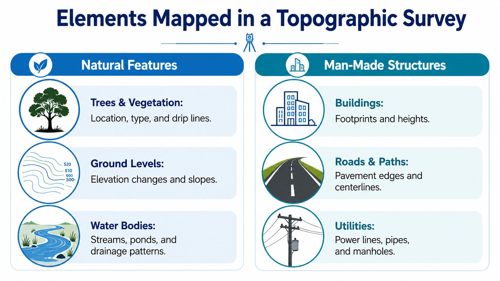
The important word is visible. A topographic survey is a surface survey. It will normally show covers, chambers, and grates that can be seen on site, but it does not by itself confirm the route, depth, or condition of underground utilities. That catches clients out. An architect may have a reliable plan of the surface and still need separate utility records, GPR, or drainage investigations before final design or approvals.
This is one of the common project gotchas. A site can look fully surveyed, yet a planning consultant, engineer, or contractor may still ask for more information because the topo answers a different question. It shows the measured surface and features affecting layout. It does not replace a utility survey, a boundary determination, or a drainage condition survey.
Survey specifications also vary with the job. A small residential redesign needs a different level of detail from a rail, highway, greenfield, brownfield, or substation scheme. The brief usually needs to pin down five things clearly: the area to be covered, the level of detail, the accuracy needed, the grid and datum to be used, and the format for the final data. If you are testing early garden concepts with landscape design ai, that can help with ideas, but the final layout still needs measured site information so steps, falls, walls, and drainage points tie back to real levels on the ground.
How contours and spot heights work
Levels are the part many clients find hardest to read at first.
Contours work like the lines on a hiking map. Each contour joins points at the same height. If those lines are close together, the ground rises or falls quickly. If they are spaced further apart, the slope is gentler.
Spot heights do a different job. They are single measured points that give the level at a precise location, such as a doorstep, the corner of a patio, the crown of a road, or the centre of a driveway.
A datum is the reference level those heights are measured from. It works like the zero line on a ruler. Without that shared reference, the numbers are far less useful because your architect, engineer, and contractor may all be measuring from different starting points.
A simple way to read the drawing is:
- Contours show the overall shape of the ground
- Spot heights confirm exact levels at key points
- Feature symbols identify surface objects and survey items
- Linework shows edges such as walls, kerbs, building outlines, fences, and hardstanding limits
That detail has practical consequences. A change in level that seems minor on site can alter step arrangements, retaining work, threshold heights, accessible access, and where rainwater will run. If those issues are spotted early on the topo, they are usually cheaper to deal with on paper than after a planning submission or during the build.
Key Triggers When You Need a Topographic Survey
Some projects clearly need a survey. Others drift into needing one after drawings start, which is usually more expensive and more frustrating. The best time to commission it is before design decisions harden.
Planning and design decisions
Planning applications often need accurate site information. Councils, architects, and consultants can't prepare dependable drawings if the base information is rough or outdated. You don't want a scheme designed around assumptions, only to find later that the site levels or existing features make it awkward to build.
Architectural design is another common trigger. If you're placing an extension near steps, a retaining wall, neighbouring structures, or a sloping garden, measured levels become central to the design. Without them, room thresholds, roof relationships, and external access can all end up needing revision.
Outdoor design projects catch people out too. A redesign may look straightforward until someone asks where the water will go. If you're using tools such as landscape design ai to explore layout ideas, that's useful for concept development, but the final scheme still needs measured site data so the design fits the ground you have on site.
Projects where levels matter more than people expect
Drainage design is one of the biggest reasons a topographic survey becomes essential. Surface water doesn't care what the sketch looked like. It follows levels. If an engineer doesn't know the fall of the site, drainage proposals are little more than educated guesses.
A few typical examples make the point:
- House extension on a sloping rear garden. The architect needs to know whether the new floor level will sit comfortably with the garden or create steps, retaining work, and awkward drainage.
- New driveway or parking area. The design needs enough fall to shed water without sending it toward the house or neighbour.
- New build on an uneven plot. Foundation design, finished floor levels, access, and cut-and-fill decisions all depend on reliable terrain data.
- Commercial yard or hard landscaping scheme. Small level errors can affect accessibility, standing water, and how materials quantities are calculated.
The trigger isn't project size. It's whether the site conditions affect permission, design, or construction. On that test, even modest domestic projects often benefit from proper topographic information.
Common Surveying Methods and Technology Explained
Surveyors don't use one tool for every site. They choose equipment to match the access, size, shape, obstruction level, and output required.
Early in the process, it's helpful to see the broad options at a glance.
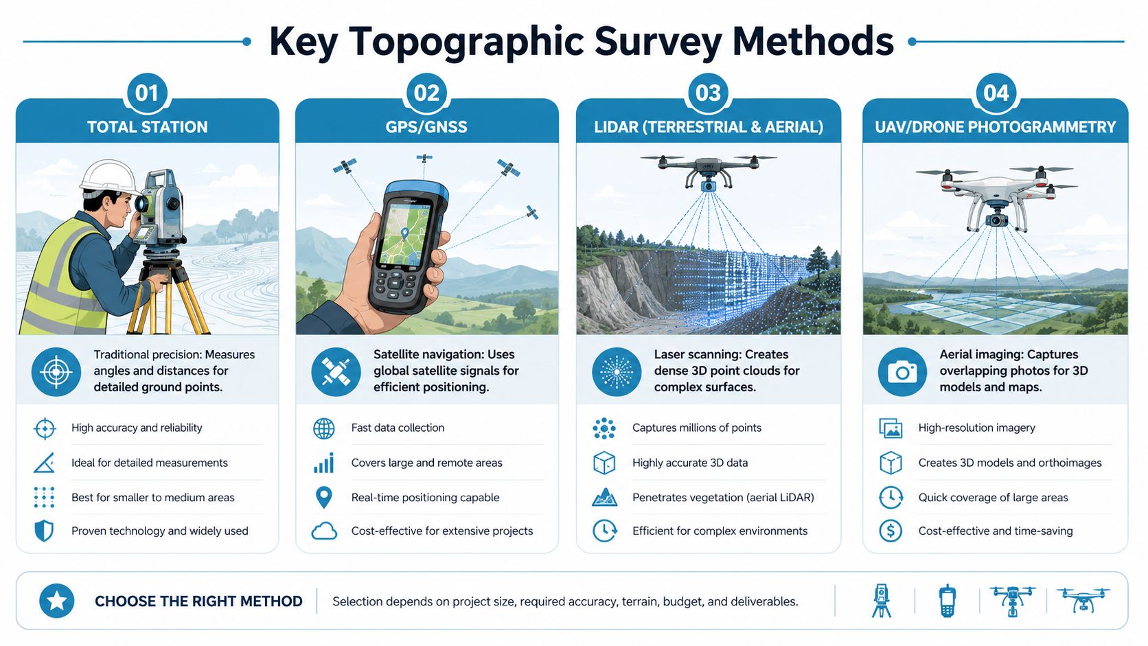
The main tools surveyors use
A Total Station is the classic precision instrument many people picture on a tripod. It measures angles and distances very accurately and is excellent for detailed work on smaller or more obstructed sites. In tight urban locations, around buildings, or where specific features need careful pickup, it's often the right choice.
GNSS, often referred to loosely as GPS, uses satellite positioning. It's useful for establishing control and for surveying larger open sites where the sky view is good. It's less suitable where trees, high walls, or dense urban surroundings interrupt the signal.
Terrestrial LiDAR uses laser scanning to capture very dense 3D data. It shines on complex sites, irregular façades, structures, and places where lots of detail is needed quickly. Instead of measuring selected points one by one, it records a cloud of points across visible surfaces.
Later in the workflow, another method often enters the picture.
Drone or UAV photogrammetry captures overlapping aerial images and turns them into mapped data. It's particularly useful on larger, open, or awkward ground. If you want a non-technical overview of where this sits in project delivery, this guide to drone surveys in construction gives a practical outside perspective.
Which method suits which site
There isn't a single "best" method. There is only the best fit.
| Method | Best suited to | Main strength |
|---|---|---|
| Total Station | Tight sites, detailed pickup, urban plots | High control over individual measured points |
| GNSS | Open land, larger sites, control setting out | Efficient positioning over wider areas |
| Terrestrial LiDAR | Complex surfaces, façades, dense detail | Rich 3D capture |
| Drone photogrammetry | Large open areas, difficult access | Fast aerial coverage |
On many jobs, surveyors combine methods. A drone may cover the broad terrain, while a Total Station or GNSS setup captures control and checks critical features. If you're interested in how this is evolving, Survey Merchant has a useful piece on the future of UK property surveys.
The technology matters less than the result. You want a surveyor who chooses tools to answer your design questions, not someone who forces the site to fit the gadget.
Understanding Your Survey Deliverables
A survey is only useful if the right people can work from it. That is where delays often start. A client receives a neat plan, sends it to the architect, and then learns the design team also needs editable drawing files, level references, and a clear note of what was and was not surveyed.
What you receive and who uses it
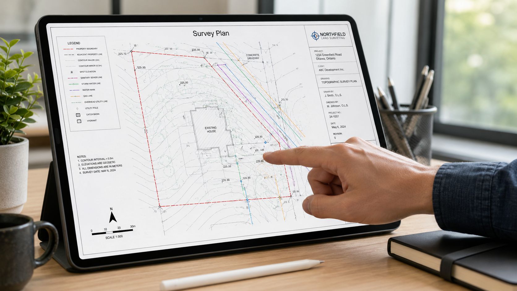
The most familiar output is a PDF plan. A property owner can open it easily, print it, mark it up, and discuss it with an architect, planning consultant, or builder. It usually shows the site layout, visible features, dimensions where needed, and level information such as contours and spot heights.
The working file for design teams is usually a CAD file, commonly DWG or DXF. That file lets an architect or engineer bring the survey straight into their software and design from measured information instead of tracing over a static image.
On more involved sites, you may also receive 3D data such as a point cloud or model references. That tends to matter where there are complex levels, retaining walls, detailed facades, or awkward existing structures. If your project also involves the building itself, not just the land around it, you may need to learn about measured surveys so you can separate site data from building data.
Why file format and reference information matter
A PDF is for reading. A CAD file is for drawing.
That difference sounds small, but it affects planning, design coordination, and contractor pricing. If your architect only receives a PDF, they may need extra time to rebuild the site in software, and every manual redraw creates room for small errors.
You may also see notes about the grid and datum. Grid is the agreed position reference across the site. Datum is the agreed height reference. A simple way to view it is this. The grid is the site's shared map, and the datum is its shared zero line for levels. If one consultant uses a different reference, a drainage design, floor level, or retaining wall height can end up misaligned.
For practical use, deliverables often break down like this:
- PDF plan for review, discussion, and planning submissions
- CAD files for architects, engineers, and technical design work
- 3D point cloud data where detailed modelling is needed
- Grid and datum information so every consultant works to the same position and level reference
The gotcha clients often miss
A topographic survey shows what is visible and measured at the surface. It does not automatically include everything a project team may later ask for.
For example, it does not usually confirm underground utilities, legal boundaries, soil conditions, or internal building layouts unless those services were separately instructed. That catches clients out more often than you might expect. A designer starts work from the topo, then planning or technical design reaches a point where utility records, a drainage survey, or a measured building survey is suddenly needed. The result is delay, extra cost, and sometimes redesign.
The sensible question to ask when ordering is not only, “What will I receive?” It is also, “What will this survey not cover, and what else might my architect, engineer, planning consultant, or contractor need next?”
If your architect asks for the CAD file rather than the PDF, they are asking for the usable drawing, not just a picture of it.
A good survey brief helps avoid that gap. Before the survey starts, check who will use the information, what software they use, whether planning or detailed design is the immediate goal, and whether the project may also need utility information or building measurements. That way, the survey supports the approval process instead of stalling it halfway through.
Topographic vs Other Common Property Surveys
Confusion can lead to significant issues. A topographic survey is only one type of survey, and it answers a specific set of questions.
What each survey is for
A topographic survey tells you the physical layout and levels of the land surface. It answers, "What's there, where is it, and how does the ground move?"
A boundary survey serves a different purpose. It focuses on the legal extent of ownership and where the property lines sit. A topographic survey may show physical features that appear to mark an edge, but that doesn't make it a legal boundary determination.
A RICS Home Survey is different again. That type of survey assesses the condition of a dwelling and highlights defects, maintenance issues, and risks for buyers or owners. It doesn't replace measured site data.
A Measured Building Survey concentrates on the building itself, often including internal layouts, floor plans, elevations, and sections. If your project involves redesigning an existing structure, you may need both the site information and building measurements. You can learn about measured surveys separately if you're trying to work out where one ends and the other begins.
| Survey Type | Primary Purpose | Key Deliverable |
|---|---|---|
| Topographic Survey | Map surface features and levels | Site plan with terrain and visible features |
| Boundary Survey | Define legal property extent | Boundary information and legal line position |
| RICS Home Survey | Assess building condition | Condition report for the property |
| Measured Building Survey | Record the building's dimensions and layout | Floor plans, elevations, sections |
The underground services misunderstanding
The biggest practical gotcha is underground utilities.
A standard topographic survey may show surface evidence such as manhole covers, gullies, valve covers, poles, or service markers. It does not legally substitute for statutory underground utility searches. XRS Geomatics notes that 22% of client complaints about topographic surveys stem from the mistaken assumption that they include complete mapping of subterranean services like gas pipes and electric cables, according to its discussion of UK topographical survey misunderstandings.
That misunderstanding matters because the drawing can look very complete. A client sees drainage covers and assumes "all the services are on there". Often, they aren't. What is visible on the surface isn't the same as a confirmed underground services record.
If your project involves excavation, foundations, service diversions, or deeper landscaping work, ask separately about utility searches or specialist service detection. Don't assume the topographic survey has already covered that ground.
UK Costs Accuracy and Choosing Your Surveyor
The price of a topographic survey depends on what has to be measured and how demanding the specification is. In the UK, a topographical survey typically costs £399 to £2,500+, depending on site complexity, according to the RICS measured surveys standard.
What affects cost and specification
A small, open, straightforward plot is quicker to survey than a large site filled with vegetation, level changes, walls, parked vehicles, and awkward access. The required detail also affects the fee. If the project needs dense level information, careful feature coding, or strict control, the work takes longer in the field and in processing.
Accuracy is also tied to scale and intended use. RICS explains that survey accuracy is scale-dependent, and gives the example that Ordnance Survey large-scale topographic mapping at 1:1250 achieves 0.9m absolute accuracy with 99% confidence. Project-specific surveys used for design work are far more precise, but the broader lesson is simple. The specification drives the method, effort, checking, and cost.
A sensible brief should state:
- The site area that needs to be covered
- The level of detail needed on features and terrain
- The intended use such as planning, drainage, or architectural design
- The required output such as PDF, DWG, or further model data
How to choose well
When appointing a surveyor, don't start with price alone. Start with suitability.
Look for:
- Relevant professional standing. RICS or equivalent credentials help show recognised standards.
- Professional Indemnity insurance. If consultants rely on the data, this matters.
- Experience on similar sites. A city infill plot and a rural development site aren't the same job.
- A clear written scope. You want to know exactly what's included and what isn't.
- Usable deliverables. Confirm that your architect or engineer will receive the formats they need.
If you want a neutral checklist before appointing anyone, this guide offers impartial property surveyor advice.
The best instruction is usually the one with the clearest brief. A surveyor can price and plan accurately when the client explains the project team, intended use, and required outputs from the start.
Frequently Asked Questions
Do I need a topographic survey for a small domestic project
Not always, but many small projects benefit from one. If the design is affected by slopes, steps, drainage, retaining walls, neighbouring structures, or awkward access, measured data can save redesign later.
Will a topographic survey show my legal boundary
Not by itself. It may show physical boundary features such as fences or walls, but legal ownership lines are a different matter and may need a boundary-focused instruction.
Does it include underground pipes and cables
You shouldn't assume that it does. Surface indicators may be shown, but underground utility information usually needs separate searches or specialist detection work.
What should I send the surveyor before they quote
A site address helps, but a better enquiry includes your proposed works, the area to be covered, and who'll use the survey. If an architect, engineer, or planning consultant is already involved, mention that too.
Is a PDF enough
For you as the client, often yes. For the design team, often no. Architects and engineers usually want CAD files so they can design directly from the measured information.
How detailed should the survey be
That depends on the job. A planning-stage domestic layout may need less detail than engineering design for drainage or retaining structures. If you're unsure, ask your architect or engineer what information they need before ordering.
How long does it take
That varies with site access, complexity, weather, and the output required. Straightforward sites move faster than heavily obstructed or technically demanding ones.
Need help finding the right survey for your property or project? Survey Merchant connects clients across the UK with qualified, multi-disciplinary surveyors for topographic surveys, measured surveys, building surveys, valuations, and more. If you're not sure what to order, start with the project you have in mind and get matched with a surveyor who fits the brief.