You're often at the same point when this question comes up. A property has been bought, a lease event is approaching, a refurbishment is taking shape, or an architect is asking for “existing drawings”. Someone forwards an old PDF floor plan, a planning set from years ago, or an estate agent sketch. It looks usable until the first design decision depends on it.
That's where problems start. A wall isn't where the drawing says it is. Floor levels don't line up. The roof geometry is incomplete. Joinery is ordered to the wrong size, or a structural engineer designs around assumptions instead of facts. By the time the error shows up on site, the team has already spent time and money designing from a false base.
A measured building survey solves that problem. It creates an accurate record of the building as it exists, not as someone thinks it exists. For architects, developers, landlords, and asset managers, that record becomes the single source of truth for design, coordination, compliance, and decision-making. If you want the practical answer to what is a measured building survey, it's this: the dataset that reduces avoidable risk before it spreads through the rest of the project.
Table of Contents
- Your Project's Foundation Accurate Building Data
- Two services with different jobs
- Measured Survey vs RICS Building Survey
Your Project's Foundation Accurate Building Data
A project often starts with confidence and ends with a redraw. An architect receives a set of old sales plans for a period house, begins testing options, and then discovers on site that wall thicknesses are wrong, floor levels step unexpectedly, and the stair opening is smaller than shown. By that point, design time has already been spent on assumptions.
A measured building survey gives the team one verified base to work from. It records the building as it stands, with dimensions, levels, openings, structural elements, and external form captured in a methodical way so designers, engineers, cost consultants, and contractors are all referring to the same information. That matters because the survey is not just a package of drawings. It is the single source of truth that reduces design risk, limits costly clashes, and helps the project move from concept to approvals, pricing, fabrication, and construction with fewer surprises.
Practical rule: If a drawing will be used to design, price, fabricate, or obtain approvals, it needs to come from measured data rather than a legacy plan.
The value is partly in what it prevents. Without reliable base information, each consultant fills gaps differently. An architect may square up a room that is slightly out. A structural engineer may set steel to dimensions taken from an outdated PDF. A joinery package may be priced against openings that are not consistent floor to floor. Small discrepancies at survey stage become expensive decisions later.
It also creates value beyond the first design package. Once accurate building data exists, it can be reused for planning drawings, interior layouts, tenancy plans, refurbishment sequencing, maintenance records, and future alterations. Clients often see the return in fewer repeat visits, less re-measuring, and cleaner coordination across the life of the asset.
If your brief includes fabric condition or repair risk as well as dimensional information, that usually sits alongside a different service, such as a Level 3 full building survey for condition and defects, rather than inside the measured survey itself.
If you work across jurisdictions, terminology can shift. This overview of the building surveyor's role in Australia is useful for comparison, especially where clients are trying to map one market's roles and deliverables onto another.
Measured Survey vs Building Survey What Is the Difference
A common failure point is the first instruction. An architect asks for a survey and receives a condition report with no usable dimensions. A buyer commissions measured plans and still has no clear advice on damp, cracking, or repair liability. The result is delay, a second fee, and decisions made without the right base information.
Two services with different jobs
A measured building survey records the building as it exists. It captures dimensions, levels, openings, wall positions, and the spatial relationship between elements, then turns that information into drawings or digital models that a design team can use.
A building survey in the RICS Level 2 or Level 3 sense examines condition. It reports on defects, deterioration, movement, moisture, repair priorities, and areas of risk in the fabric of the property.
That distinction matters on live projects. If the brief is an extension, fit-out, refurbishment, lease plan, or asset record, the measured survey is the single source of truth the rest of the team works from. If the brief is pre-purchase advice, repair planning, or understanding whether visible defects point to a larger problem, the building survey is the right instruction.
The outputs are different because the purpose is different. Measured survey work produces scaled floor plans, elevations, sections, reflected ceiling plans, 3D models, or point cloud data. A building survey produces a written assessment with photographs, commentary, and repair guidance. It may include indicative dimensions, but not design-grade geometry.
If you are buying a property, defect-led advice often comes first. Material on pre-purchase building inspections can help set expectations for that type of inspection. For a UK service focused on condition, defects, and repair risk, a full Level 3 building survey sits in that category rather than the measured one.
Measured Survey vs RICS Building Survey
| Feature | Measured Building Survey | RICS Level 3 Building Survey |
|---|---|---|
| Primary purpose | Records accurate dimensions and spatial data for design, coordination, and record purposes | Assesses condition, defects, repair issues, and building risks |
| Typical output | Scaled floor plans, elevations, sections, CAD files, point cloud, BIM model | Written report with commentary on fabric, defects, maintenance, and condition |
| Best used for | Extensions, refurbishments, fit-outs, planning, lease plans, reinstatement, asset records | Pre-purchase due diligence, repair planning, defect diagnosis |
| Can an architect design from it? | Yes, if the scope and level of detail match the design need | No, it does not replace measured drawings |
| Focus on defects | Limited unless defects recording is separately instructed | Central to the inspection |
| Focus on dimensions | Core service | Secondary and usually not suitable for design |
Clients sometimes ask which survey is "better". That is the wrong test. The right question is which risk needs to be removed first.
For design and delivery risk, accurate measured data prevents setting-out errors, coordination clashes, and procurement based on the wrong geometry. For ownership and condition risk, a building survey helps identify defects, likely causes, and repair exposure. On many projects, both are needed, but they are not interchangeable.
Choose the wrong one and the problem shows up later. The design team redraws from poor information, contractors price with assumptions, or a purchaser proceeds without understanding the condition of the asset.
How a Measured Building Survey Is Done
Modern measured survey work doesn't rely on one person walking around with a tape. The process is now digital, layered, and far more reliable than many clients expect.

The site capture process
A typical survey starts with a scope review. The surveyor needs to know what the drawings will be used for, which areas are included, what level of detail is needed, and whether the output will be 2D CAD, point cloud, or BIM. That early conversation affects everything that follows.
On site, 3D laser scanning is now a primary capture method for many buildings. Modern scanners used in UK measured surveys can generate millions of laser pulses per second, producing point clouds with ±1–3mm per point accuracy, and those datasets are then processed into final drawings meeting the RICS standard of ±5mm accuracy according to this step-by-step guide. For the client, the practical point is simple. The scanner captures dense spatial information quickly and consistently.
A scan by itself isn't the whole job. Surveyors still have to plan station positions, manage line of sight, capture concealed transitions, confirm control, and check that critical features haven't been missed. The equipment helps, but method matters more than marketing.
Why multiple tools are often used together
Most competent measured surveyors combine several methods rather than forcing one tool to do everything.
- Laser scanner for interior and external geometry. This creates the point cloud that underpins plans, elevations, sections, and models.
- Total station for control. It establishes precise reference points and ties the survey into a coordinate framework where needed.
- Photogrammetry for roofs and façades. This is particularly useful where access is awkward or the roof form is too complex to capture from the ground alone.
- Manual checks for verification. Door swings, service zones, hidden void access, and awkward details still need judgement and selective checking.
For properties with complex roofscapes, tall elevations, or difficult access, drone-supported capture is often the practical answer. If you want a broader view of where that fits, this guide to drone survey benefits for UK property owners in 2026 gives helpful context on when aerial data improves coverage.
A short demonstration helps make the workflow clearer:
Good survey work isn't about owning impressive hardware. It's about using the right capture method for the building, then processing the data into drawings people can actually build from.
What doesn't work is under-scoping the instruction. If nobody agrees at the start whether the team needs reflected ceiling plans, roof plans, principal heights, or structural grids, the survey may be accurate but still incomplete for the project.
What You Get Understanding the Deliverables
A measured building survey only protects the project if the outputs match the decisions your team needs to make. A drawing package that looks complete can still leave gaps that cause redesign, coordination errors, or site queries later. The true value is not the number of files issued. It is getting a reliable base record that everyone can work from with confidence.
The agreed deliverables usually fall into two groups. First, there are drawing outputs used immediately by architects, engineers, planners, and contractors. Second, there are data-rich outputs that support coordination, phased refurbishment, and building management over time.
The core drawing set
A standard measured building survey can include floor plans, external elevations, sections, roof plans, internal and external levels, and structural grids with principal heights. The right combination depends on the brief, the building, and the design risk.
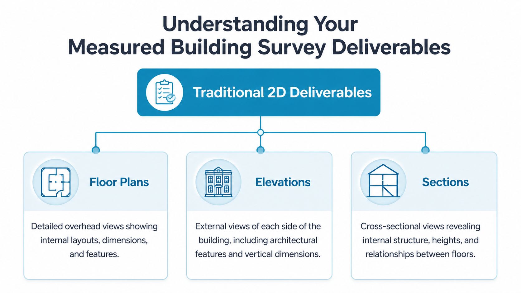
Each deliverable answers a different project question:
- Floor plans record room layout, wall thickness, openings, circulation routes, and dimensions needed for design development.
- Elevations show the outside faces of the building, including openings, visible features, and vertical alignment across the façade.
- Sections cut through the building to show floor-to-floor heights, ceiling form, stair geometry, and how spaces relate vertically.
- Roof plans help where plant, drainage runs, rooflights, parapets, or complex forms affect design and access.
- Levels and principal heights give engineers and contractors fixed reference information for setting out, structural appraisal, and coordination.
For many projects, this drawing set becomes the single source of truth for the existing building. If that baseline is wrong, every design package built on top of it inherits the same error. If it is correctly scoped and clearly presented, the team can test options early, price work with fewer assumptions, and avoid wasting time resolving basic dimensional disputes.
One practical point matters here. Clients often ask for "plans, elevations, and sections" because that is the standard wording. A better approach is to specify what the team needs to decide. A planning application may need existing elevations and roof plans. A structural engineer may need sections, levels, and grid information first. A CAT A office refurbishment may need reflected ceiling plans and service zone information because coordination risk sits above the ceiling, not at floor level.
Point clouds and BIM models
Laser scanning usually produces a point cloud, which is a three-dimensional set of measured points representing the building's surfaces. It is not usually the final document issued to every consultant, but it is often the evidence base behind the drawings and any later modelling.
A BIM-integrated measured survey adds another layer. Instead of geometry alone, the output can include modelled elements with attached information such as asset references, materials, or maintenance-related data, depending on the agreed scope. That can be useful where the survey is expected to support more than one design stage or where the building will be managed actively after works.
The advantage is practical. A 2D drawing is often enough for a small fit-out or domestic alteration. A model starts to justify its cost where several disciplines need to coordinate in the same digital environment, where works will be phased, or where the building owner wants a reliable record for future alterations and maintenance. The trade-off is time, modelling level, and fee. Not every point captured in a scan should be modelled, and not every project benefits from paying for that extra step.
Typical cases where richer outputs earn their keep include:
- Refurbishment projects where architecture, structure, and building services must be coordinated in one model.
- Facilities and asset management where plant, fittings, and spatial data need an organised record.
- Adaptive reuse schemes where the building will continue to change and updated "as-built" information has lasting value.
- Compliance and audit tasks where reflected ceiling plans, access information, or data-linked elements help consultants document decisions clearly.
A good deliverable set does more than describe the building. It reduces uncertainty before planning, design, pricing, and construction start. That is why the scope should be agreed with care at the outset. The survey is not just a drawing exercise. It is the project record your team will keep returning to when accuracy matters.
Common Use Cases and Core Benefits
A developer prices a refurbishment from old landlord plans. An architect starts layouts from a PDF that looks close enough. Once site checks begin, wall lines drift, floor levels do not match the record, and service routes sit where the new design needs to go. That is how delay and redesign start. A measured building survey prevents that by giving the project one reliable reference point before decisions harden into cost.

Where measured surveys earn their keep
Measured surveys create value anywhere an existing building has to be understood properly before money is committed.
For architects and interior designers, the survey sets out the actual geometry of the space for layouts, planning drawings, joinery, and detailing. If a wall bows, a column is off-grid, or ceiling heights vary across a floorplate, that needs to be known before design coordination starts.
For developers and contractors, the survey reduces risk at tender stage and during pre-construction review. Existing structures often contain the constraints that decide whether a scheme is straightforward, awkward, or expensive. Good survey data helps teams test access, sequencing, demolition extent, and buildability against the building as it stands, not as someone remembers it.
For commercial owners and landlords, measured data supports lease plans, area checks, fit-out records, and future alterations. Over the life of an asset, that record becomes more than a drawing set. It becomes the reference used by agents, project managers, consultants, and facilities teams when decisions need to be made quickly.
For heritage and sensitive buildings, the method matters as much as the output. Laser scanning and related capture techniques can record irregular or delicate fabric with limited physical contact, which is one reason these surveys are widely used on older buildings. If you are comparing providers, it also helps to review broader market options beyond your immediate shortlist. Guides such as find top land surveyors can help frame the questions to ask.
The tangible benefits for clients
The benefit is control.
A measured survey gives the whole team a single source of truth. That improves design decisions, reduces avoidable re-measuring, and lowers the chance of discovering basic dimensional problems after planning, pricing, or manufacture has started.
In practice, the gains usually show up in a few predictable places:
- Design coordination. Proposed work can be checked against real walls, levels, openings, and structure before clashes reach site.
- Procurement. Staircases, joinery, glazing, partitions, and other made-to-measure items can be ordered against verified dimensions.
- Planning and approvals. Existing drawings are easier to defend when they reflect the building accurately and clearly.
- Site efficiency. Contractors spend less time stopping to confirm dimensions that should have been resolved before mobilisation.
- Risk management. Constraints are identified earlier, when changes are cheaper and easier to manage.
The cheapest survey fee rarely produces the lowest project cost.
There is also a longer-term return. Once a detailed measured survey is in place, later phases and future works start with a usable record rather than another round of basic site capture. For active property owners, that saves time each time the building is altered, re-let, or reviewed.
The trade-off is straightforward. A fuller survey scope costs more at the start, and not every project needs every elevation, section, reflected ceiling plan, or modelled element. But under-scoping the survey often shifts cost into redesign, delay, and site queries, which is usually the more expensive place to solve missing information.
Clients get the best result when the survey is commissioned early and briefed properly. If you need help choosing the right provider, this guide on how to find the right surveyor is a practical place to start.
Finding the Right Surveyor with Survey Merchant
A measured building survey is only as useful as the brief and the person producing it. Choosing the right surveyor matters because two quotations that sound similar on paper can lead to very different outputs.
Questions worth asking before you instruct
Start with the scope. Ask what will be surveyed, what won't, and how inaccessible areas are handled. Clarify the expected deliverables in plain language. If your architect needs floor plans, elevations, sections, and a point cloud, say so directly.
Then ask practical questions such as:
- What accuracy standard do you work to? A serious provider should be able to explain tolerance and quality control clearly.
- What technology will you use on this building? Laser scanning, total station control, and photogrammetry each suit different conditions.
- Can I see sample outputs? You're not looking for pretty graphics. You're checking whether the drawings are clear, usable, and appropriately detailed.
- Who processes the data? Some firms capture well but outsource modelling in a way that introduces delays or misunderstandings.
- How do you deal with access constraints or occupied buildings? This affects programme and completeness.
If you're comparing providers more broadly, it can help to read outside your immediate shortlist. Industry round-ups such as this guide to find top land surveyors can be useful for understanding what separates a specialist survey practice from a generic supplier. For a more direct UK-focused route, this article on how to find the right surveyor covers the selection process in practical terms.
How to judge the quote, not just the price
The lowest price isn't always the lowest cost to the project. A quote may exclude key outputs, omit difficult areas, or assume a lower level of detail than the design team needs.
Check these points before accepting any proposal:
| What to review | Why it matters |
|---|---|
| Deliverables listed clearly | Prevents disputes about what drawings or files are included |
| Level of detail defined | Stops under-modelled outputs that can't support the intended design stage |
| Access assumptions stated | Highlights whether roofs, basements, plant rooms, or restricted areas are excluded |
| File formats confirmed | Ensures your architect or consultant can use the output without conversion issues |
| Programme explained | Helps the project team plan around site work and drawing issue dates |
A good instruction is specific. It identifies the use case, confirms the output, and avoids vague wording like “survey for renovation”. That phrase can mean ten different things to ten different firms.
If you need a measured building survey, Survey Merchant helps you find the right fit without guessing. The platform matches instructions with qualified, insured surveyors across the UK, so whether you need accurate existing drawings for a house extension, a point cloud for a complex refurbishment, or a BIM-ready survey for a commercial asset, you can source the right expertise and a competitive quote with far less friction.