Building Surveying
Jul 16, 2026
Drone for Roof Inspection: Your UK Guide
Considering a drone for roof inspection in the UK? Discover benefits, CAA rules, costs, and how to find a qualified surveyor.

A roof problem usually starts with uncertainty, not drama. You notice a damp patch after heavy rain, spot a slipped slate from the garden, or your buyer's survey flags “further investigation recommended” and suddenly a simple question becomes awkward: how do you inspect the roof properly without turning the first visit into a ladder, scaffold, or access headache?
That's where a drone for roof inspection has become useful in UK practice. It doesn't replace judgement, and it doesn't make every roof survey automatic. What it does is let a qualified operator gather clear visual evidence from the air while the surveyor stays on the ground. For many homes, that's the safest and fastest way to decide whether the issue is minor maintenance, a repair programme, or a defect that needs a closer physical inspection.
A common example is the post-storm phone call. A homeowner has found bits of slate in the driveway, a managing agent has a tenant reporting water ingress near a chimney breast, or a buyer wants clarity before exchange. The old answer was often a roofer with a ladder for a quick look, or scaffold if the access looked awkward. That can still be necessary, but it shouldn't be the default first move on every property.
For a large share of UK homes, the better first question is simpler: can the roof be inspected safely from the ground and from the air before anyone steps onto it? If the answer is yes, a drone survey gives you current-condition imagery that's usually far more useful than guessing from street level.
That matters most on brittle coverings, steep pitches, and roofs with difficult access over conservatories, rear extensions, or narrow side returns. It also helps when several parties need the same evidence, such as an owner, insurer, contractor, and solicitor. If you want a parallel view of how roof defects are approached in another market, this round-up of expert advice on Dallas roof inspections is useful for comparison because the inspection logic is similar even where regulation and roof construction differ.
Where a broader condition review is needed, clients often combine a drone inspection with formal roofing survey services so the imagery feeds directly into defect diagnosis, repair advice, and negotiations.
A drone roof inspection is a remote visual inspection carried out with an unmanned aircraft capturing high-resolution photos and video of the roof covering, edges, junctions, and associated elements such as chimneys, valleys, flashings, parapets, and gutters. In some jobs, the workflow also includes thermal imaging or model-building from overlapping stills. In practice, that turns a risky access task into a controlled data-capture exercise.
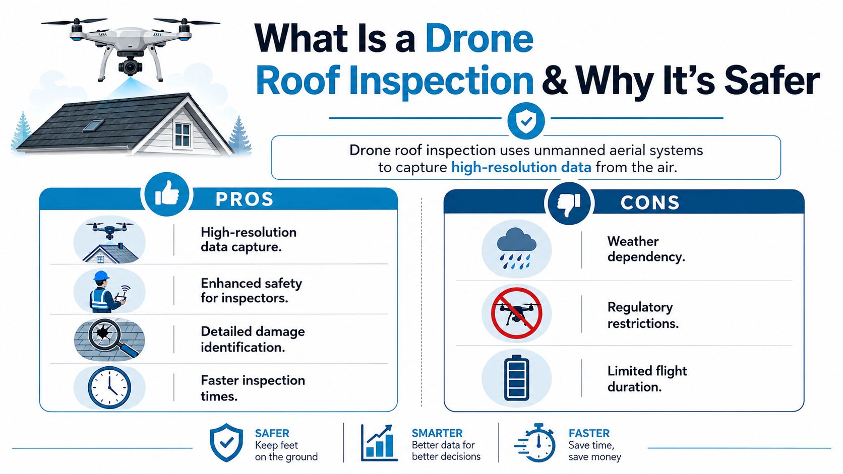
The strongest reason this method has become mainstream in UK property work is safety. The Health and Safety Executive reported that 35 construction workers were killed in work-related incidents in 2023/24, and falls from height remain one of the major causes of fatal injury in the sector, as noted in this drone roof inspection market review. Roof inspection sits squarely inside that risk category because it often involves ladders, fragile coverings, limited landing points, and awkward access.
On a typical residential instruction, the issue isn't just whether someone can physically get up there. It's whether they should. A quick ladder look might seem straightforward until you add wet moss, old slates, shallow gutters, or a client who wants evidence rather than opinion.
Practical rule: If the initial purpose is to identify visible defects and decide whether further access is needed, remote capture is usually the more defensible first step.
That's especially true for pre-purchase work, storm checks, and defect investigations where the roof may not be safe to walk, or where walking it could cause further disturbance. A drone can't remove every risk, but it shifts the inspection method away from direct exposure at height.
For property owners wanting a broader overview of how this fits into building inspections, this guide to drone survey benefits for UK property owners gives useful context.
Later in the process, a visual explanation helps. This short video gives a practical sense of what aerial roof capture looks like on site.
Safer doesn't mean effortless. Flights still need proper planning, a lawful operating environment, suitable weather, and a competent pilot. It also doesn't mean drones replace every close inspection. Sometimes the drone result is, “Yes, there's visible damage here, and now we need a roofer or surveyor to inspect one localised area physically.”
That's a good outcome. It narrows the invasive part of the job to the part that needs it.
The best use of a drone for roof inspection is to answer a disciplined question: what can be confirmed from high-quality aerial imagery, and what still needs another method?
For visible defects, drones are excellent. They can usually identify slipped or missing slates and tiles, damaged ridge details, obvious flashing issues, chimney defects, blocked gutters, vegetation build-up, impact damage, and many forms of post-storm displacement. On British housing stock, that covers a lot of the problems clients need verified before instructing repairs.
Aerial imagery is strongest where the defect has a visible expression on the surface. Common examples include:
Dense visual coverage is especially helpful on roofs with multiple planes, rear additions, dormers, or inaccessible valleys. It gives the surveyor time to review detail calmly rather than relying on a fleeting look from a ladder position.
There's a limit that clients need to understand from the outset. RICS guidance emphasises that aerial imagery is one part of the process, best for identifying slipped slates, chimney defects, and storm damage, but cannot diagnose hidden issues like underlay failure or timber decay, which may still need close-up inspection, as summarised in this discussion of drone use for roof inspections.
That distinction matters. A drone may show no obvious missing tiles, yet the property can still have a leak caused by failed underfelt, porous mortar bedding, defective rooflights, or condensation-related issues inside the loft. It may show staining around a valley, but not reveal the full cause without internal inspection or selective opening up.
A sharp image isn't the same thing as a full diagnosis.
In day-to-day surveying, the right question isn't “Is a drone enough?” It's “Enough for what?”
| Purpose | Drone survey suitability | Likely need for further access |
|---|---|---|
| Confirm visible storm damage | High | Sometimes |
| Check slipped slates or broken tiles | High | Sometimes |
| Review gutters, flashings, chimney heads | High | Sometimes |
| Diagnose intermittent leak source | Moderate | Often |
| Assess hidden timber decay | Low | Usually |
| Confirm underlay failure | Low | Usually |
The strongest reports are honest about that boundary. If a pilot or contractor claims the drone alone can prove every roof defect, treat that as a warning sign rather than a selling point.
The legal side decides whether a roof can be inspected at all, not just how good the camera is. On many UK jobs, the true challenge isn't imaging. It's airspace, separation distances, safe launch space, and whether the site can be operated lawfully without exposing members of the public.

For roof work in the UK, the main baseline is the Civil Aviation Authority framework. The CAA states drones must not be flown over, or within 50 m of, a congested area unless the operator has permission, and the standard height limit is 400 ft (120 m), as set out in this guide to drone roof inspection rules. On a built-up residential street, that changes the entire job plan.
A detached house with a large garden is one thing. A Victorian terrace on a narrow street is another. The operator may have overhead constraints, limited take-off and landing space, parked cars, pedestrians, and neighbours close to the likely flight path.
That's why the sensible first filter is go or no-go, not enthusiasm. A qualified operator normally checks:
A property can be perfectly suitable for inspection as a building and still unsuitable for drone deployment on that day.
Clients often ask a fair question: what about neighbours and privacy? On domestic instructions, the answer isn't to ignore it. It's to manage it professionally.
A competent operator captures only what is needed for the instruction, avoids unnecessary hovering over adjoining spaces, stores images securely, and limits distribution to the parties who need the survey evidence. If neighbouring windows, gardens, or people appear incidentally, that should be treated as data that needs careful handling, not casual sharing.
Client check: Ask how imagery is stored, who receives it, and how long it is retained.
The practical result is that legality sits at the front of the process. If the site can't be flown safely and lawfully, the correct answer is no. That's part of professional competence, not a failure of the technology.
Not every aerial roof job produces survey-grade evidence. Some produce attractive photos. That isn't the same thing. If you want measurements, reliable defect mapping, or a model that another professional can review, the capture method matters as much as the drone itself.
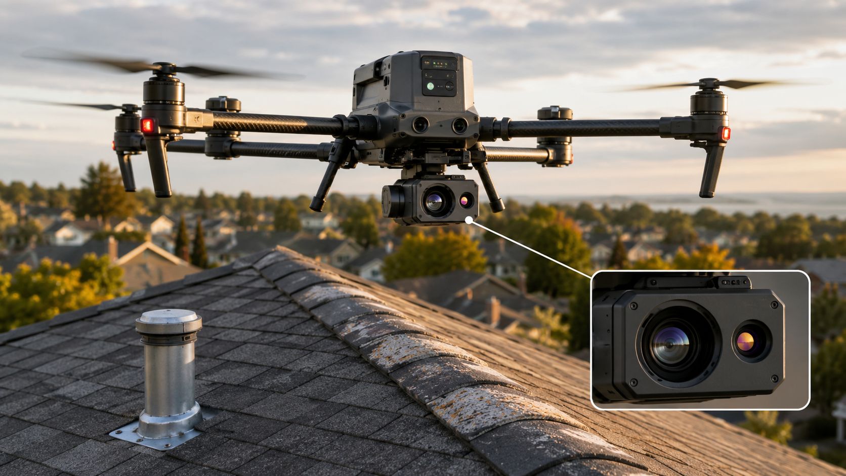
The strongest outputs come from structured photogrammetry rather than improvised flying. Survey-grade roof missions typically use 20 MP+ cameras and 80% image overlap, allowing photogrammetry software to reconstruct a scale-accurate 3D model and support deliverables such as defect area estimation and slope assessment, according to DJI's roof inspection guidance.
A single close-up can show a broken tile. It can't build a dependable roof model. For that, the operator needs dense, overlapping imagery from consistent angles so the software can match common points across multiple frames.
That's where terms like orthomosaic, 3D mesh, and photogrammetry become relevant. They aren't marketing jargon when used properly. They describe how separate images become a measurable dataset rather than a loose photo album.
A good roof mission usually includes:
Some inspections also use thermal imaging or LiDAR. These can be valuable, but only if the instruction justifies them and the operator understands the limitations. Thermal imaging may help indicate moisture ingress patterns or insulation issues. LiDAR can assist on some complex geometry tasks. Neither should be treated as magic.
What clients should ask is more basic. Are you getting the right data for the question at hand?
If the purpose is visible defect identification, a well-planned visual survey often does more than an expensive sensor used badly.
When vetting an operator, listen for method rather than gadget talk. The better conversations mention flight planning, overlap, model accuracy, output format, and how findings will be interpreted. The weaker ones focus only on drone brand or headline video quality.
Useful questions include:
That's the difference between seeing the roof and understanding it.
A professional drone roof inspection should feel organised from the client side. You're not paying for someone to turn up, fly around for a few minutes, and email random images. You're commissioning a workflow that turns aerial capture into evidence you can act on.
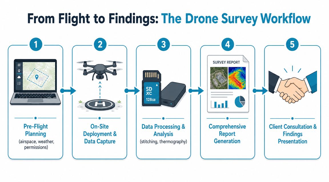
In current practice, modern drone workflows can inspect a roof within minutes, with processing that turns imagery into measurable roof models and reports in hours, and that speed is particularly relevant in insurance work after storm events, as explained in this roof inspection software overview.
The job usually starts before anyone visits site. The operator checks weather, airspace, access constraints, and the property context. The client may be asked for photos from ground level, the postcode, known defects, and whether neighbouring land or a rear garden provides the safest operating position.
For clients comparing options, specialist property drone surveying services often make this first-stage triage easier because the scope is defined properly before the visit.
On arrival, the operator completes the final risk assessment and confirms the launch area, likely flight path, and public exposure. If conditions aren't right, the flight may be delayed or abandoned. That's exactly what should happen.
Once cleared, the aircraft captures a mix of overview images and detail shots. On some jobs, the capture is mostly manual to inspect a specific defect. On others, it follows a structured mission to create a model.
This is the part clients don't see, and it's where much of the value sits. Images are reviewed, processed, and organised into outputs that another person can understand without being on site.
Typical deliverables include:
Good reporting separates observation from conclusion. “Lead flashing appears displaced” is an observation. “This is the sole cause of internal damp” may be a conclusion that still needs corroboration.
The most useful reports answer three practical questions:
| Client question | What the report should show |
|---|---|
| What can you see? | Clear annotated imagery |
| How serious is it? | Defect commentary and priority |
| What happens next? | Advice on monitoring, repair, or further inspection |
That's why a drone inspection works best when it produces findings, not just footage.
The fastest way to waste money on a drone inspection is to buy one on price alone. Cheap flying is easy to find. Competent evidence gathering is harder. For UK property work, you need someone who understands aviation compliance, site risk, image capture, and the difference between a visible defect and a proper diagnosis.
Ask direct questions. A capable operator should answer them plainly and without evasiveness.
Check for:
The weak operators tend to reveal themselves quickly.
A professional operator should be comfortable saying, “This site may need another access method,” or, “The drone will identify the visible issue, but not the hidden cause.”
A homeowner can certainly buy a consumer drone. That doesn't make the output suitable for a purchase negotiation, a dispute, a formal maintenance decision, or an insurance discussion. The issue isn't just flying. It's lawful operation, image quality, completeness, record keeping, and informed interpretation.
If the roof matters, treat the inspection as evidence, not content.
If you ask only one thing, ask this: What decision will your report help me make?
A good answer might be that the survey will help you decide whether the roof needs immediate repair, whether further invasive inspection is justified, or whether the issue appears localised and suitable for routine maintenance. That keeps the appointment anchored to property judgement rather than gadget appeal.
Some of the best contractor-vetting advice is simple and transferable. These Moore Construction Co. hiring tips are worth reading because the core principle is the same for drone operators and roof contractors alike: ask how they work, what they carry, and what evidence they provide.
| Question | Answer |
|---|---|
| Can a drone inspect a flat roof? | Yes. Flat roofs are often well suited to drone inspection because the aircraft can capture membrane condition, outlets, edge details, ponding indicators, and parapet junctions from angles that are hard to assess from ground level. Hidden moisture or trapped water may still need specialist follow-up. |
| Can it be done in bad weather? | Usually not. Rain, poor visibility, and unsuitable wind conditions can make the flight unsafe or reduce data quality. A reschedule is normal and often the right decision. |
| Will the inspection disturb neighbours? | Disruption is usually limited, but residential work still needs sensible planning. Good operators choose careful launch positions, minimise unnecessary hovering, and manage imagery responsibly. |
| Can the report help with an insurance claim? | It can support a claim by providing clear visual evidence of current roof condition. Whether that is sufficient for the insurer is a separate question, and some claims still require additional inspections or contractor input. |
| Does a drone replace a roofer or surveyor? | No. It is a capture tool. The value comes from pairing the imagery with competent interpretation and, where necessary, targeted physical follow-up. |
| Are terraced houses always suitable? | Not always. Tight urban sites, public exposure, restricted launch space, and local airspace constraints can make some properties no-go for drone deployment on a given day. |
A good roof inspection doesn't start with the aircraft. It starts with the decision about whether the aircraft is the right tool for this property, in this location, for this question.
If you need impartial help finding the right surveyor for a roof concern, pre-purchase issue, defect investigation, or drone inspection, Survey Merchant connects property owners and professionals with qualified UK survey specialists who can advise on the right inspection route and the evidence you need.
Survey Merchant provides vetted RICS surveyors across 100+ UK locations at fixed fees:
→ Level 2 Home Survey (HomeBuyer Report)
→ Level 3 Building Survey (full structural survey)
→ RICS Red Book property valuations
→ Party wall surveyors — notices, awards & schedules of condition
→ Expert witness surveyors — CPR Part 35 reports for property disputes