Building Surveying
Jul 16, 2026
What does a measured survey include: 2026 guide
Discover what does a measured survey include in this 2026 guide. Ensure accurate building details for planning, renovation, and sales.

A measured survey is a detailed, scaled architectural record of a building’s physical dimensions, produced to recognised professional standards. Property buyers and homeowners commission one when they need accurate drawings of an existing building, whether for planning permission, renovation design, or a sale. Understanding what does a measured survey include helps you specify the right deliverables, avoid costly gaps in information, and protect your investment from the outset.
A measured building survey captures the physical reality of a building as it currently exists, not as it was originally designed. Old architectural drawings are frequently unreliable because buildings change through renovations, extensions, and structural settling. Relying on legacy plans can cause serious design errors, so a fresh measured survey gives you verified data to work from.
The core deliverables of a measured survey are:
Deliverables are typically supplied as DWG and PDF files. For complex projects, surveyors can also produce 3D BIM or Revit models and laser-scan point clouds, which enable clash detection and support modern digital design workflows.

The Royal Institution of Chartered Surveyors sets the measurement standards that all professional surveyors must follow. Since Q2 2026, RICS mandates that every survey report documents the measurement basis used, applying either the Code of Measuring Practice (6th edition) or IPMS: All Buildings. This replaces the archived RICS Property Measurement 2nd Edition. The change matters because inconsistent measurement bases produce different floor area figures for the same building, which directly affects valuation and planning decisions.
Accuracy in a measured survey is expressed through tolerances. Professional surveys are typically accurate to within 10mm, with different tolerances applied to different elements through a process called accuracy banding. A large structural wall carries a different acceptable tolerance than a door reveal. Clients should specify the required accuracy level at the point of instruction, not after the survey is complete.
The legal implications are significant. RICS-regulated surveyors carry professional indemnity insurance and produce work that can withstand planning authority scrutiny. A survey produced outside these standards risks rejection at planning stage, which costs time and money to rectify.
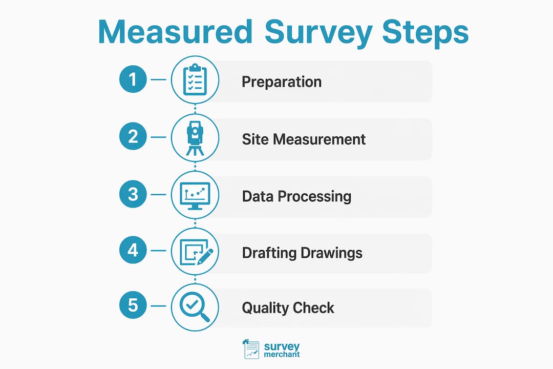
The mandatory steps for a compliant survey are:
Pro Tip: Ask your surveyor to confirm in writing which measurement standard they will apply before any site visit takes place. This single step protects you if a planning authority or mortgage lender later queries the figures.
Property buyers frequently confuse a measured survey with a condition survey or a valuation. Each serves a distinct purpose, and commissioning the wrong one wastes money and time.
A measured survey focuses entirely on geometry and dimensions to produce scaled architectural drawings. It tells you the size and shape of the building with precision. It does not assess the condition of the structure, identify defects, or comment on value.
A condition survey, such as a RICS Level 3 Building Survey, inspects the structural integrity of the building and identifies defects, damp, and maintenance issues. It produces a written report, not scaled drawings. Both survey types are often needed together for major renovation projects, where you need accurate drawings and a clear picture of the building’s condition simultaneously.
A topographic survey maps site features beyond the building footprint, including ground levels, trees, boundaries, and drainage runs. It is the correct choice when a project involves landscaping, new access roads, or external works. A boundary survey uses GPS or total station equipment to verify the legal extent of a land parcel against title deeds. It does not produce architectural drawings.
| Survey type | Primary output | Typical use |
|---|---|---|
| Measured building survey | Scaled 2D CAD drawings, optional 3D models | Renovation design, planning applications, extensions |
| Condition survey (Level 3) | Written defect report | Pre-purchase inspection, maintenance planning |
| Topographic survey | Site plan with levels and features | Landscaping, drainage, external works |
| Boundary survey | Legal boundary delineation | Boundary disputes, land registration |
For a broader view of construction survey types, the distinctions between these categories become clearer when you consider the intended end use of the data.
The level of detail required from a measured survey depends entirely on what you intend to do with it. A survey produced for marketing photographs needs far less detail than one produced for a structural renovation or a planning application. Agreeing the specification upfront is the single most effective way to avoid planning delays and unexpected costs.
For a straightforward property sale or marketing exercise, floor plans and external elevations are usually sufficient. For a loft conversion or rear extension, you will also need building sections showing existing ceiling heights and roof structure. For a full refurbishment, reflected ceiling plans, service riser drawings, and structural depth measurements become necessary. Each additional element adds cost and time to the survey, so specifying only what you need keeps the project efficient.
The following elements are worth discussing with your surveyor before instruction:
Homeowners should define their goals clearly before commissioning any survey, rather than relying on a mortgage valuation alone. A mortgage valuation is not a survey. It is a brief assessment for the lender’s benefit and provides no architectural data whatsoever.
Pro Tip: Request a sample drawing from your surveyor before instruction. Reviewing their standard output confirms the level of detail, drawing conventions, and file formats match your architect’s or designer’s requirements.
Understanding construction compliance standards also helps homeowners appreciate why measurement accuracy matters beyond the drawing itself, particularly when projects require regulatory sign-off.
A measured survey is the only reliable way to obtain accurate, legally defensible architectural drawings of an existing building, and its components must be specified to match your project’s exact needs.
| Point | Details |
|---|---|
| Core deliverables | Floor plans, elevations, sections, and roof plans form the standard output of every measured survey. |
| RICS standards apply | Since Q2 2026, surveyors must document the measurement basis used, applying the Code of Measuring Practice 6th edition or IPMS. |
| Accuracy tolerances matter | Professional surveys are accurate to within 10mm; agree tolerances at instruction, not after the survey is complete. |
| Not a condition survey | A measured survey records dimensions only. A separate condition survey is needed to assess defects and structural integrity. |
| Specify before instructing | Define the required elements and accuracy level upfront to avoid planning delays and cost overruns. |
The most common mistake I see is homeowners treating a measured survey as a box-ticking exercise rather than a foundational design tool. They commission the cheapest option available, receive floor plans that lack wall thicknesses or ceiling heights, and then discover three months into a renovation that their architect cannot use the drawings. That costs far more to fix than a properly specified survey would have cost in the first place.
The second mistake is assuming that because a building has existing drawings, a new survey is unnecessary. Buildings change. A Victorian terrace that has had a rear extension, a loft conversion, and a kitchen knockthrough in the past forty years bears little resemblance to its original plans. Measured surveys reflect the building as it actually stands, accounting for every undocumented modification. That accuracy is what makes them worth commissioning.
My strong recommendation is to use a RICS-qualified surveyor for any measured survey that will support a planning application or a significant renovation. The professional indemnity insurance alone justifies the cost. If a planning authority rejects drawings on technical grounds, you need a surveyor who can defend their methodology. An unregulated provider cannot do that.
— Surveymerchant
Commissioning the right survey from a qualified professional is the most direct way to protect your property investment and keep your project on track.

Surveymerchant connects property buyers and homeowners with RICS-regulated surveyors across the UK, covering everything from standard measured building surveys to full Level 3 building surveys for complex properties. Every surveyor on the Surveymerchant panel works to current RICS standards, including the 2026 measurement guidance, so your drawings are fit for planning applications, mortgage lenders, and design teams from day one. You can also access building surveying services tailored to your specific project scope, whether you need a basic floor plan package or a full 3D BIM output.
A standard measured survey includes 2D CAD floor plans, external elevations, building sections, and a roof plan. Reflected ceiling plans and 3D BIM models are available as optional additions depending on project requirements.
Professional measured surveys are typically accurate to within 10mm. Accuracy tolerances vary by element and should be agreed with the surveyor at the point of instruction.
A measured survey produces scaled architectural drawings showing dimensions and geometry. A building survey, such as a RICS Level 3, is a written condition report identifying defects and structural issues. They serve different purposes and are often used together for major renovation projects.
Planning authorities require accurate scaled drawings of the existing building as part of most planning applications. A measured survey is the standard method for producing those drawings to the required level of accuracy and professional defensibility.
Since Q2 2026, surveyors must document their measurement basis using either the Code of Measuring Practice (6th edition) or IPMS: All Buildings. The previous RICS Property Measurement 2nd Edition has been archived and no longer applies.
Survey Merchant provides vetted RICS surveyors across 100+ UK locations at fixed fees:
→ Level 2 Home Survey (HomeBuyer Report)
→ Level 3 Building Survey (full structural survey)
→ RICS Red Book property valuations
→ Party wall surveyors — notices, awards & schedules of condition
→ Expert witness surveyors — CPR Part 35 reports for property disputes